Earth science
Elephant Butte Reservoir falls to 1.4% as Landsat maps the retreat
A July 27 image captured New Mexico’s largest reservoir near a late-July trough; Reclamation records put its storage at the lowest level since 1971.
Add us as a preferred source on Google Add us as a preferred source on Google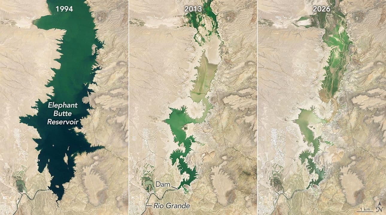
Elephant Butte Reservoir held 27,483 acre-feet of water on July 27, 2026, the day Landsat 9 imaged New Mexico’s largest reservoir. NASA Earth Observatory, which published the comparison on August 19, paired that scene with water-volume records and placed the lake at 1.4% of capacity—its lowest level since 1971. Bureau of Reclamation data show storage slipped further to 26,732 acre-feet on July 29 before beginning a modest rise. The result is both a reading in a daily record and a landscape-scale view of the reservoir’s remaining surface-water footprint.
By August 18, the latest date in Reclamation’s series when NASA published its analysis, storage had reached 27,323 acre-feet. That was 591 acre-feet above the July 29 minimum but still about 1.4% on the capacity basis used by NASA. Reclamation labels the daily measurements provisional and subject to revision. The dates matter: the Landsat scene records conditions on July 27, while the later gauge readings show the small changes that followed.
Three Landsat dates, one water record
NASA’s comparison sets three views of the same reservoir side by side. Elephant Butte was nearly full when Landsat 5’s Thematic Mapper acquired the first scene on June 2, 1994. Landsat 8’s Operational Land Imager recorded the reservoir at its 2013 annual low of 2.9% on July 8 that year. The July 27, 2026 scene came from Landsat 9. NASA Earth Observatory produced the comparison from Landsat data supplied by the U.S. Geological Survey and paired it with water-volume data from the Texas Water Development Board.
The 1.4% figure did not come from counting blue pixels in the satellite image. NASA cites the water record for volume and Landsat for the view from orbit. Used together, the two sources answer different questions: the gauge record measures how much water was stored on a given date, while the image shows where the visible surface-water footprint had retreated across the reservoir basin. That distinction keeps the satellite scene from being mistaken for a stand-alone capacity measurement.
Record snow loss met scheduled releases
The National Integrated Drought Information System reported on May 14 that New Mexico’s 2026 peak snowpack was the lowest in the Snow Telemetry record. By then, snow had melted from every monitored site in the state except one, and sites that had melted out did so an average of 44 days early. NASA linked that early loss of mountain snow, along with several years of extreme drought in the Rio Grande basin, to the reservoir’s decline. Snowpack normally stores part of the basin’s cold-season precipitation for release later in the year, so an early melt changes the timing of water reaching rivers and reservoirs.
The reservoir was also being drawn down for irrigation. In a July 22 notice, New Mexico State Parks said the Bureau of Reclamation had confirmed that releases would continue through July 28. The Reclamation record places the storage minimum one day later. NASA said the end of agricultural releases allowed the lake to begin refilling slowly. The sequence distinguishes the long drought and early snowmelt behind the basin’s limited supply from the operating decision that shaped the timing of the late-July low; the available sources do not quantify a separate share for each factor.
A smaller lake changed the shoreline
Low water was already changing access at Elephant Butte Lake State Park before the satellite acquisition. The park remained open, but the State Parks Division was clearing exposed shoreline debris, adjusting boat-ramp access and using a long-reach excavator to remove silt and debris from the Marina del Sur ramp. It warned visitors about soft or unstable shoreline zones, newly exposed hazards and shallow, unfamiliar water. NASA’s Landsat comparison supplies the wider geographic context for those ground-level changes.
An overhead image cannot show how much water any farm, town or legal entitlement will receive. Nor can one scene separate the effects of drought, releases and groundwater use. NASA noted that users in New Mexico and Texas depend on both surface water and groundwater in the Rio Grande valley, making storage and sharing decisions a management problem rather than an image-reading exercise. The satellite view becomes useful for water security only when it is read with gauge data, operational records and measurements on the ground.
What the satellite view adds
The Landsat archive makes the 2026 scene more informative than a single photograph. The three NASA views preserve the reservoir’s geography while spanning 32 years, making it possible to compare the near-full footprint of 1994 with the drought low of 2013 and the still smaller percentage recorded in 2026. The daily water series supplies the precision the images lack: it identifies July 29 as the low point in the current record and tracks the few hundred acre-feet added afterward. In combination, the sources show both the extent and the amount of the loss.
NASA says its Western Water Action Office is supporting applications that extend that combination beyond a visual comparison. One project incorporates satellite measurements related to soil moisture and evapotranspiration into a near-real-time tool designed to complement local irrigation-allocation work. Another combines satellite observations of water-surface height with drone and ground data to examine how groundwater pumping affects Rio Grande flow. Those projects show the intended management role for Earth observation, although the NASA article does not provide an independent assessment of their performance.
Reclamation’s August 18 reading left Elephant Butte at 27,323 acre-feet, close to the late-July minimum and still near 1.4% of capacity. Later measurements may revise the provisional series or record further refill, but they cannot change what the dated Landsat comparison establishes: on July 27, the reservoir’s visible footprint coincided with its lowest storage period since 1971. The gauge fixes the amount; the satellite view fixes that low-water condition in place and across the basin.
Reporting trail
Primary sources
NASA Earth ObservatoryElephant Butte Reservoir Runs Lowscience.nasa.gov
Bureau of Reclamation RISEElephant Butte Reservoir Dam and Powerplant Daily Lake/Reservoir Storage-af Time Series Datadata.usbr.gov
Drought.govSnow Drought Current Conditions and Impacts in the Westdrought.gov
New Mexico Energy, Minerals and Natural Resources DepartmentUpdate on low water levels at Elephant Butte Lake State Parkemnrd.nm.gov
For an image post, download the card and copy this suggested caption.
A July 27 image captured New Mexico’s largest reservoir near a late-July trough; Reclamation records put its storage at the lowest level since 1971. Read the full report: https://www.spaceexploration.in/news/elephant-butte-reservoir-1-4-percent-landsat #SpaceExplorationNews #SpaceNews #SpaceScience